"Retaining an undisturbed...view shed is essential to retaining a feeling for this important landscape and what it has meant historically for defining New Mexico's southwestern character."
--Written of La Bajada Mesa, New Mexico Heritage Preservation Alliance, Most Endangered Places.~ Rural Conservation Alliance Archives To: RCA History, January 2006--"Buildology" application was withdrawn Note that applicants tried again in 2008 as "Rockology" and likewise withdrew
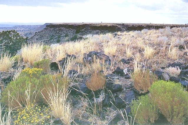 |
Photo copyright Patrick Allen Mohn 2005.
Back in 2005, before the current "Rockology" application, there had been a previous "Buildology" application to start a basalt strip mine to crush "aggregates for construction purposes". This was for ~108 acres on La Bajada Mesa, the scenic and historically important landform to the south of Santa Fe, NM and west of the Cerrillos Hills Historic Park. (To 2005 application / map)
The applicants, Steven Hooper, (Buildology, Inc.); James Siebert of Santa Fe, (agent); Peter Naumburg & Hugh Graham, (owners/speculators: Buena Vista Estates, Inc.), withdrew their application only to resubmit in 2008 under the new name, Rockology.
County staff said in 2005 that the applicants were having so many problems, including lack of water for dust control, that they had to back off. County staff was in the process of recommending denial when the applicants withdrew ~2006. But the staff's draft Recommendation also stated that "this location is not compatible or suitable for mining." They went on to write that the Mesa had been listed as one of New Mexico's "Most Endangered Places. and that "this demonstrates the cultural significance and importance of protecting this area."
In 2008, the same applicants and speculators returned (CDRC Case - Rockology). And citizens of Santa Fe & the County needed again to make sure the County staff AND representatives got the message that "this location is not compatible or suitable for mining." Go to SaveLaBajadaMesa.org !
As we enter into year 2013 we again find a renewed effort by Buena Vista to set the stage for mining through acquisition of water rights "for sand and gravel washing and dust control" that includes the same lands as before.
Steven Hooper, applicant (Buildology, Inc.)
--in the Public Record, County of Santa Fe--
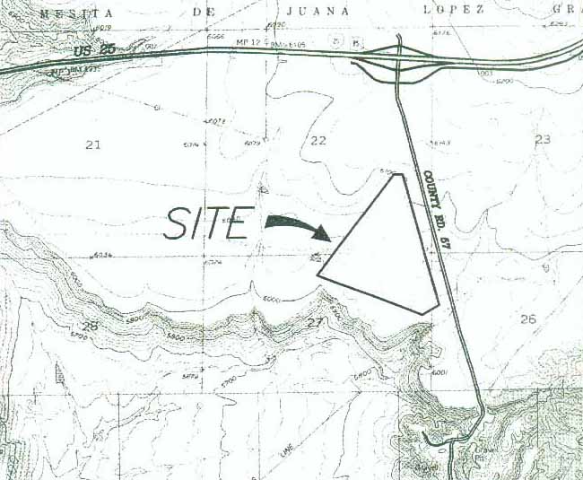
Image shows a triangular drawing of a "108 .5 acres" zone approximately 3000 feet to a side, placed several 100 feet to the south of CR 57 and several 1000 feet from I-25.
[Cover text]:
PROPOSAL FOR CONSTRUCTION MATERIALS EXTRACTION ON 108.49 ± ACRE SITE
LOCATED IN TOWNSHIP 15N. RANGE 7E, SECTIONS 22, 26 AND 27
SANTA FE COUNTY, NEW MEXICO
Submitted By:
James W. Siebert and Associates, Inc.
915 Mercer St.
Santa Fe, New Mexico, 87503
Prepared For
Buildology, Inc.
3601 Pan American Frwy. NE
Albuquerque, New Mexico 87107
March, 2005
==============
Table of Contents
Description [&] Page Number
1.0 Introduction 1-3
1.1 Owners of Record
1.2 Project Location
1.3 Adjacent Property Owners
1.4 Neighboring Uses
1.5 History of Mining in the Area
2.0 Mineral Resources 3-4
2.1 Availability
2.2 Type of Material
3.0 Operations Plan 4
3.1 Time Frame
3.2 Hours of Operation
4.0 Materials Processing 4-5
4.1 Pit Operations
4.2 Plant Processing
4.3 Product Loading and Distribution
4.4 Hazardous Materials
4.5 Structures
5.0 Utilities & Outdoor Lighting
6
5.1 Utilities
5.2 Lighting
6.0 Environmental Review 7-10
6.1 Air Quality
6.2 Storm Water/Drainage Management
6.3 Archaeological Review
6.4 Soils
7.0 Water, Liquid and Solid Waste
10-11
7.1 Water Budget
7.2 Liquid Waste
7.3 Solid Waste
8.0 Access and Traffic Impacts 11-12
9.0 Reclamation 14
10.1(sic) [9.1] Procedure
10.2(sic) [9.2] Revegetation
===============
Figures
Figure 1 Vicinity Map
Figure 2 Traffic Movements
Tables
Table 1 Volumetric Calculations
Table 2 Annual Use of Non-Potable Water
Table 3 Traffic Generation
Table 4 Seed Mix
Appendix A Sheriff's
Deed
Appendix B Description of Material
Found prepared by Buildology, Inc. [Letter, Applicant Steve Hooper
to Jerry Geist and Peter Naumburg]
Appendix C Completed Site Threshold
Form
==============
1.0 Introduction
Buildology Inc, [Steve Hooper owner; James Siebert applicant] a New Mexico Corporation is proposing a Mining Zone to allow the extraction of aggregates for construction purposes to be used in ready-mix concrete, asphalt, landscaping, and base course. The basaltic material is a durable, sound aggregate, which is needed in construction of roads, bridges, homes, buildings, and public works projects. The quality of the aggregates pits in the Santa Fe area generally do not meet the requirements for these types of construction projects.
1.1 Owners of Record
The owner of this 1,060 ± acre tract is Buena Vista [Peter Naumburg & Hugh Graham], 1160, L.L.C. This tract of land was the subject of a lawsuit and the title was secured through a Sheriff's Deed as the result of a foreclosure on the property. The Sheriffs Deed pertaining to this tract of land is found in Appendix A to this report.
1.2 Project Location
The subject site is located east of Interstate 25 and south of Waldo Canyon Road (County Road 57). Figure 1 is a vicinity map which describes the location of this 106 acre parcel of land. The subject 108.49 ± acres is located within Township 15N, Range 7E, Sections 22, 26 and 27.
1.3 Adjacent Property Owners
The subject site is entirely surrounded by land owned by the co-applicant for this project. Adjoiners to the larger Buena Vista 1190 acre parcel are:
To the East:
Larry Peppler
Mesita de Juana de Santa Fe LTD
Box ---
Cerrillos, New Mexico 87010
To the South:
Happy Valley LTD
P.O. Box ----
Santa Fe, New Mexico 87502
To the North:
Martha Harris
---- Arroyo Chamisa Rd. NE
Albuquerque, New Mexico 87111
To the West:
Remainder of Buena Vista Properties
[end page 1]
================
[page 2, map & drawing of mining
site & vicinity, above]
================
1.4 Neighboring Uses
The majority of the land in the area surrounding the subject tract is vacant. The closest physical feature is County Road 57 to the east and 1-25 to the north. Waldo Canyon Road (CR57) is located 300 feet to the east of the northern-most boundary of the site. The closest existing use to this application is a sand and gravel mining operation located to the southeast of this site, This sand and gravel mining operation is owned and operated by Espanola Mercantile, Inc.
1.5 History of Mining in the Area
Espanola Mercantile, Inc. began its sand and gravel mining operation in the mid 1990's. All of Waldo Canyon Road from the entry to the sand and gravel operation to the asphalt from the 1-25 project was paved as part of an effort to reduce dust on Waldo Canyon Road created by trucks accessing the mining site. During the construction of 1-25, a mining construction site was established immediately east of the subject tract for the purpose of extracting borrow material and for sand and gravel for making base course and asphalt aggregates for the interstate highway construction.
A gypsum mining and processing plant was located on the Santo Domingo Pueblo to the south and west of this proposed development. A railroad siding was constructed by the Atchison, Topeka and Santa Fe Railroad line for the purpose of loading aggregate ballast material to be used for bedding of the railway. This siding is located to the south and west of this site.
Mining has an extensive history in this area of Santa Fe County.
2.0 Mineral Resources
2.1 Availability
A soils investigation of the site was conducted using an excavator to determine the type and depth of material. A description of the material found at the site prepared by Buildology Inc. is found in Appendix B to the report. Basaltic material was found to the limits of the depth that can be achieved by the excavator, or approximately 20 feet. Except for 4-6 inches of top soil the basaltic material was relatively constant for the entire depth of 20 feet.
[end page 3]
============
2.2 Type of Material
The principal material located within the mineral extraction area is basalt. Physical property testing demonstrates that the material is high quality, meeting soundness and durability specifications. The physical properties as tested are:
Bulk specific gravity: 2.64
Absorption: 3.2%
L.A. abrasion: 20.9%
Magnesium Sulfate Soundness Loss: 7.1%
Sodium Soundness: 1 -5%
This information is derived from testing conducted by Steven A. Hooper, P.E. and owner of Buildology, Inc.
3.0 Operations Plan
3.1 Time Frame
The initial mining operation is expected to last 15 - 20 years with the operation to be conducted in three phases. A materials stock pile and crusher will be located in each of the three pits to be excavated over a 15 year period. The mining for each cell will occur over an approximate five year period. Each cell will be reclaimed and revegetated after the mining of the cell is complete.
3.2 Hours of Operation
During the warmer months (April - September) the hours of operation will be 7:00 AM to 5:00 PM for weekdays and 7:00 to 12:00 on Saturdays. During the colder months (October through March) the hours of operation during the weekday will be 9:00 to 4:00. Work will generally not take place on the weekends during the colder months.
4.0 Materials Processing
The processing and handling of materials will be accomplished in three phases; pit operations, plant processing and product loading and distribution.
4.1 Pit Operations
Preparation of each cell begins with the removal of natural soil overburden. A track dozer will be used to remove the overburden to expose the basaltic rock formation. The overburden will be stockpiled outside the excavation cell and will be used as topsoil in the reclamation of the site following completion of mining for each phase.
[end page 4]
===============
Three cells are proposed for the site. The location, phasing and acreage for the cells is found in the plan set submitted with this application.
Rock drilling will follow the removal of overburden, drilled in accordance with the written and approved blasting plan. A licensed and insured blaster will perform the blasting operations in compliance with Santa Fe County and federal ATF regulations. Blasting will only take place during daytime hours. Times for blasting will be coordinated to insure that regulatory agencies are properly notified, Blasting materials will not be stored on site.
4.2 Plant Processing
A front-end loader will feed the blasted material into a feed hopper, followed by crushing, screening and stockpiling of finished material. The crusher will be located in the excavated cell with limited visibility from public roadways. Conveyors will be used to deliver materials into different size components. Unusable material is returned to the excavation area for use in reclamation.
4.3 Product Loading and Distribution
This component of the operation consists of a front-end loader placing the finished aggregate products into the haul trucks. All trucks will be required to be compliant with New Mexico Department of Transportation and New Mexico Public Regulation Commission requirements. All loads will be weighed to ensure that trucks are within the legal weight limits, and properly covered to secure the load.
4.4 Hazardous Materials
Standard hazardous materials used in aggregate processing are petroleum-based products such as diesel fuel, lubricants, and oils. These products will be stored in accordance with local, state and federal regulation. A spill prevention plan will be in place and administered by the operations superintendent, who receives annual training on spill prevention. A five thousand gallon diesel fuel storage tank will be used for heavy equipment operating on the proposed site. The tank will be padlocked and have a secondary containment system will consist of a ten mil geosynthetic line and earthen berm to contain spills equal to I 10 percent of the tank's volume.
Other petroleum products will be stored and used according to industry standards and regulations. A service truck will visit the site on a weekly basis to serve the equipment located at the site. Servicing of equipment will be done in conformance with State regulations for disposing of waste materials and equipment oils.
4.5 Structures
No permanent structures will be constructed within the proposed project area. Only temporary and portable structures will be placed on the site to serve the mining operation.
[end page 5]
=================
These structures will include a too] trailer, administrative trailer, screening and crushing equipment and associated belt conveyor systems, water and fuel storage tanks and weigh scale.
5.0 Utilities & Outdoor Lighting
5.1 Utilities
The only public utility that will be extended to the site will be electricity. An electric line is being installed adjacent to the site for the purpose of providing electric service to telecommunication towers to the north of this site. A transformer will be located in the vicinity of the project capable of accommodating the demands of this project. Cell phones will be used as the source of telecommunication to and from the site. Natural gas is located at the far north end of the property. This is a high pressure main that serves Santa Fe and Los Alamos. It is not financially practical to install a pressure reducing station for relative minimum use that would occur at this site.
5.2 Lighting
Lighting will be used at the tool and administrative trailers to provide the necessary security to avoid vandalism at the site. Pole-mounted lights will not exceed 20 feet in height and will have cut-off shields to direct light downward. Upon completion of the cell the height of the lights and the ground level will be approximately the same. The observance of light from outside the property will be limited.
[end page 6]
============
6.0 Environmental Review
6.1 Air Quality
The air quality plan will comply with the requirements for the permit issued by the New Mexico Environment Department for the crusher that was previously located at another location. The air quality permit information for this existing permit is:
GCP-2-3164,
IDEA No. 22537-PRN20040001,
AIRS No.350130065,
Permitted Production Rate is 500 THP.
The process equipment will include the following:
* 2 Primary Jaw Crushers with feeders
* Vertical Shaft Impact Crusher
* 2 Cone Crushers
* Surge Bin
* 2 - 6x2O Screens
* I - 8x20 Screen
* I - 6x 18 Screen
* 1000 KW Generator
* 18 conveyors
In addition the following actions will be implemented at this site:
--The road to the excavation area will be constructed to
County standards for base course roads and dust palliatives will
be used on an as needed basis to manage
particulates from traffic on the haul road.
--Dust suppression systems will be installed at the processing area and the material transfer sites using atomized for sprays.
--Employees will be trained in recording-keeping for daily monitoring of opacity at the site.
--Finished stockpile material will be located in an area
that is protected as much
as possible from the prevailing winds.
6.2 Storm Water/Drainage Management
George Gonzalez, PE, has prepared a grading and drainage plan for the site. This plan is included in the plan set submitted with this application. Ponding locations are described
[end page 7]
===============
for each phase of the project. Each cell will be graded to direct storm water to these ponds. The site does not disturb any significant natural drainages and any runoff from the cells will be contained entirely within the cell. Since it is not feasible to drain the ponds by natural methods the water will have to evapotransporate from the retention ponds. If standing water remains in the ponds for more the five days a portable pump will be used to reclaim the water. The recovered water will be stored in the water tank that serves for dust mitigation measures.
A Storm Water Pollution Prevention Plan (SWPPP), as required by the E.P.A., will be prepared prior to the issuance of a development permit for the mining application. The plan will include the location of silt fences and measures to be taken to ensure the storm water from the site does not cause erosion problems either as part of the mining process or from access roads to the site.
[end page 8]
==============
6.3 Archaeological Review
This request is not located within an area of "Historic or Cultural Sites" as designated in the County Land Development Code. It is located within an area designated on Map 8, "Santa Fe County Archaeological Districts", as having moderate potential for archaeological sites. Prior to the issuance of a development permit a qualified archaeologist will prepare an archaeological survey and report for the site. If qualifying sites are found they will either be mitigated according to the requirements and standards of the State Historic Preservation Office or a non-disturb easement will be placed on the property, avoiding any excavation of the site.
6.4 Soils
Based on findings from the Natural Resources Conservation Service Soils NRCS, there is only one type of soils profile associated with the mineral excavation site. This soils type is described below.
110:
Cuerbio Loam 1
-3 Percent Slopes
Setting
Landform: Mesas
and erosional fan rermiants
Position on landforrn: Summits
Subsurface Geology: Silty
alluvium of the Ancha Formation and
basalt
bedrock of the Cerros del Rio volcanic field
Shape of areas: Irregular
Size of areas: 10
to 300 acres
Elevation: 5,800
to 6,700 feet
135:
Tsinat Gravelly Loam I
- 6 Percent Slopes
Setting
Landform:
Mesas
Position on landform: Summits
Subsurface Geology: Basalt
bedrock of the Cerros del Rio Volcanic field
Shape of Area: Irregular
Size of Areas: 100
to 300 acres
Elevation: 6,000
to 6,500 feet
[end page 9]
================
136:
Chunipa Very Cobbly Sandy Loam 5
- 15 Percent Slopes
Setting
Landform: Mesas
Position on landform: Beveled
summits and shoulders
Subsurface Geology: Basalt
bedrock of the Cerros del Rio Volcanic field
Shape of Area: Irregular
Size of Areas: 50
to 200 acres
Elevation: 6,000
to 6,500 feet
7.0 Water, Liquid and Solid Waste
7.1 Water Budget
Water for dust control purposes will be brought from the City wastewater treatment plant to the site and stored in the 10,000 gallon tank. Trucks will shuttle the water in off peak hour periods for use during periods that dust control is needed. The effluent water trucks will have non-potable water use written on the side of the trucks and notice posted on the site that non-potable water is used for dust control purposes. The limited water needed for drinking purposes will be purchased in twenty gallon containers. For potable water ten to twenty gallons will be used on a daily basis for drinking purposes.
[end page 10]
==============
The water use for dust control is described on Table 2.
Table 2
Annual Use of Non-Potable Water
Month Gals./Month
January 30,000
February 30,000
March 140,000
April 140,000
May 140,000
June 40,000
July 40,000
August 40,000
September 40,000
October 40,000
November 30,000
Total 710,000
7.2 Liquid Waste
Portable toilets will be brought to the site for sanitary purposes for the workers. A specified maintenance period will be included in the contract for service of the portable toilets.
7.3 Solid Waste
The only solid waste produced on the site will be associated with the trash generated by the workers associated with eating lunch at the plant. This trash, to be placed in bags, will be returned to the Buildology offices in Albuquerque for disposal.
8.0 Access and Traffic Impacts
Trucks will access the site from 1-25 and Waldo Canyon Road. Waldo Canyon Road is currently paved up to the access to the property. The distance from 1-25, measured along Waldo Road, to the access point is approximately 1.3 mile. An access road will be constructed to the site. Top soil from the access road to the site will be stockpiled along with the top soil from the excavation for the cell. A borrow ditch will be cut on each side of the road to manage storm water. Storm water ponds will be created at selected points along the roadway to prevent any increase in historic runoff from the site. The access road to the first cell will be approximately 0.4 mile in length. This road will serve as the access road for all three phases and as a maintenance road for the underground electric line. The access road will not be reclaimed since it will continue to be used as the maintenance road for the underground electric line.
[end page 11]
=============
During maximum operation it is estimated that twelve trucks will haul materials from the site on a daily basis. It is also assumed that at peak capacity, ten persons will be working at the site. Table 3 is an estimate of traffic generation at the site. Figure 2 describes the traffic movements for the AM peak hour, which is the peak hour with the greatest traffic volumes. The completed Site Threshold Assessment form is provided in Appendix E (sic) [Appendix C].
Table 3
Traffic Generation
AM Peak Enter / Peak Exit / PM Peak Enter / Peak Exit
Trucks 6
/
6
/ 8
/
6
Work Vehicles 10
/
10
/
12
/
8
Total 16
/ 16
/
20
/
14
Traffic movement estimates are based on traffic from other Buildology work sites. There are fewer than 1000 vehicles per day, per lane on County Road 57 and a Site Traffic Analysis is not required, based on the criteria set forth in the State Access Management Manual published by NMDOT.
[end page 12]
================
Figure 2 "Peak Hour Traffic Movements" [diagram of
corner of Waldo Canyon Rd & I-25]
[page 13]
================
9.0 Reclamation
9.1 Procedure
Reclamation will take place upon completion of each phase of
the operation. The sides
of the excavation area will be shaped at cut slopes not to exceed
a ratio of one vertical to three horizontal. The side slopes
of the excavation area will conform to the requirements of the
Mining Safety and Health Administration. The stock-piled overburden
will be returned to the site and use as a base for the reseeding
operations. Where the terrain contours are susceptible to erosion,
furrows will be created at appropriate intervals to prevent soil
erosion. Since the excavation area does not disturb any significant
drainage channels there will be no need to restore the preexisting
drainage patterns.
9.2 Revegetation
Reseeding of the area will occur within six months of terminating the extraction process for each phase. A qualified contractor will be responsible for performing the reseeding operation. Seed will be spread on the site according to the following specifications.
Table 4
Seed Mix
Botanical Name
Common Name PLS/ac
Boutelova Gracitus Blue
Grama 2.0
lbs.
Boutelova Cestipendula Side
Oats Grama 4.0
lbs.
Sporobulus Alroides Alkali
Scaton 0.5
lbs.
Andropogen Scoporioum Little
Bluestern 1.0
lbs.
Atriplex Canescens Fourwing
Saltbush 1.0
lbs.
Fallugia Paradoxa Apache
Plume 1.0
lbs.
Fertilizer (23-13-0) shall be applied at a rate of 75 lbs per acre and prairie hay shall be applied at a rate of 1,000 lbs/acre. Hydro seeding will be used where steep slopes prevent the use of a range drill. Hydro seeding will include a binder agent for securing seed, mulch and fertilizer.
Reseeding will occur only during the months of June, July and August for warm season species and October, November and December for the cool season species. Seeded areas will be protected from livestock grazing until a vegetative cover is established.
[end page 14]
================
APPENDICES:
Appendix B: Description of Material Found, Prepared by Buildogy (sic), Inc.
CONSTRUCTION MATERIALS A DESIGN
BUILDOLOGY
3601 Pan American Freeway NE
Albuquerque NM 87108
October 10, 2003
Mr. Jerry Geist
Mr. Peter Naumberg (sic)
931 San Pedro SE
Albuquerque NM 87108
Re: Waldo Aggregate Geology
Dear Mr. Geist and Mr. Naumberg,
Per your request, this is written to give a general description of the aggregates available and the anticipated physical properties of these materials on the lands owned by Waldo Aggregates, Partnership. It should be noted that this is based on my observations and study of the property, which has not yet included actual physical testing. Interested parties should conduct appropriate testing in order to determine actual physical properties and verify actual quantities of materials in place.
Within the approximate 11,000 acres, there are several geological formations containing significant quantities of construction aggregate resources. These include monzonite, rhyolite, pediment deposits, basalt, and outcrop sediments of the Santa Fe group.
1. Monzonite - currently being mined in the area, monzonite is a hard and durable material the meets all the properties to be used for construction purposes, including aggregate for hot mix asphalt, ready-mix concrete, base course railroad ballast, riprap and landscaping. These deposits will need to be quarried, requiring overburden removal, drilling, blasting, and crushing with large jaw and/or impact crushers for size reduction. Monzonite has a low Los Angeles abrasion property, resulting in normal to high wear costs in crushing and screening components.
2. Basalt - large deposits of basalt lie predominantly on the west side of the property. Although no formal testing has been done, visual observations and discussions with others indicates this material may also be used for construction aggregates. Visually the depth of material appears to be significant, ranging from 50'-100'. This, however, may be misleading, according to random drill tests performed by a contractor in this area, which indicated average material depths in the 20-25' range. Through selective exploration it is possible to establish durable quality aggregate in the flow rock. Ordinarily, the best rock is exposed near the edges of the flows.
3. Rhyolite - minor outcroppings of rhyolite exist. These sources are questionable in quality for construction aggregates, typically having a high Los Angeles abrasion loss, high soundness loss, and low specific gravity.
4. Santa Fe formation - as is the case with rhyolite, the Santa Fe formation will be of questionable quality for construction aggregates. Certain deposits may contain marginally acceptable physical properties for construction uses, however the marketability for this material will be primarily for landscaping ground cover.
5. Pediment deposits - fair quality pediment deposits occur within the property, cropping out in recent erosion channels. These deposits contain cobble rock and medium graded rock, mixed with igneous and sedimentary materials, with fair abrasive and soundness qualities. Selective subsurface exploration can develop pits suitable for primary construction jobs.
A summary of these materials and the expected range of physical properties:
L.A.
Wear Sodium
Soundness Specific
Gravity Absorption
Monzonite 20-30%
<10%
2.6-2.7
<1.5%
Basalt 25-40%
5-20%
2.55-2.65 <5%
Rhyolite 30-50%
10-25%
2.30-2.50
<5%
Santa Fe 30-50%
10-25%
2.40-2.55
<3%
Pediment 25-35%
5-20%
2.6-2.65
<2%
From a quantitative perspective, the monzonite and basalt will most likely yield the greatest reserves. Using a conservative estimate of 20' depths, these materials will yield approximately 65,000 tons per acre. The other materials will Yield approximately 45,000 tons per acre assuming 20' depths.
Again, please note that this information was derived from visual observations, general knowledge of the aggregates historically mined in the area, and state highway department information regarding aggregate resources. Actual field testing needs to be done to ensure quantitative and qualitative requirements are met.
Please do not hesitate to contact me if you have any questions or comments.
Regards,
Steven A. Hooper, P.E.
===============
Appendix C: Site Threshold Assessment form [undated with application]
[answered items transcribed here; answers in italics]
Applicant: Steven Hooper
Business Name: Buildology Inc.
Business address: 3601 Pan American Frwy. NE
City: Albuquerque, NM 87107
Site Description
Development Type: Other, Mining
Employees: 10
The STH examines existing roadway volumes and anticipated site trip generation for the purpose of determining if additional analyses are required. If the site characteristics and the trip generation estimate for a proposed development do not satisfy the requirements for a STA or a TIA as determined by the District Traffic Engineer, the STH should be approved and the traffic study requirement for the proposed development will be complete. If additional analysis is required based on the results of the STH, the District Traffic Engineer should indicate to the applicant the level of analysis that is required.
Existing Roadway Data
Highway No.: CR 57 (Waldo Canyon Rd) Site
Mile Post: N/A
Highway ADT: 2 Less than 1000 vpdpl
Number of Lanes (two-way): 2
Trip Generation
ITE Trip Generation Land Use Category: N/A
AM Peak Hour Trips Enter:
16 Exit:
316
PM Peak Hour Trips Enter:
20 Exit:
14
Exceeds Threshold: Y or N If Yes, is a STA or TIA Required?
Notes: Traffic on CR 57 is less than 1000 vehicles per day per lane.
[End of application text]
dedicated to the preservation and protection of the natural resources and rural character
of the Galisteo Basin area of Santa Fe County, New Mexico.
--Comments, opinions of the RCA, POB 245, Cerrillos, NM 87010--
To: RCA News 2015 Here!